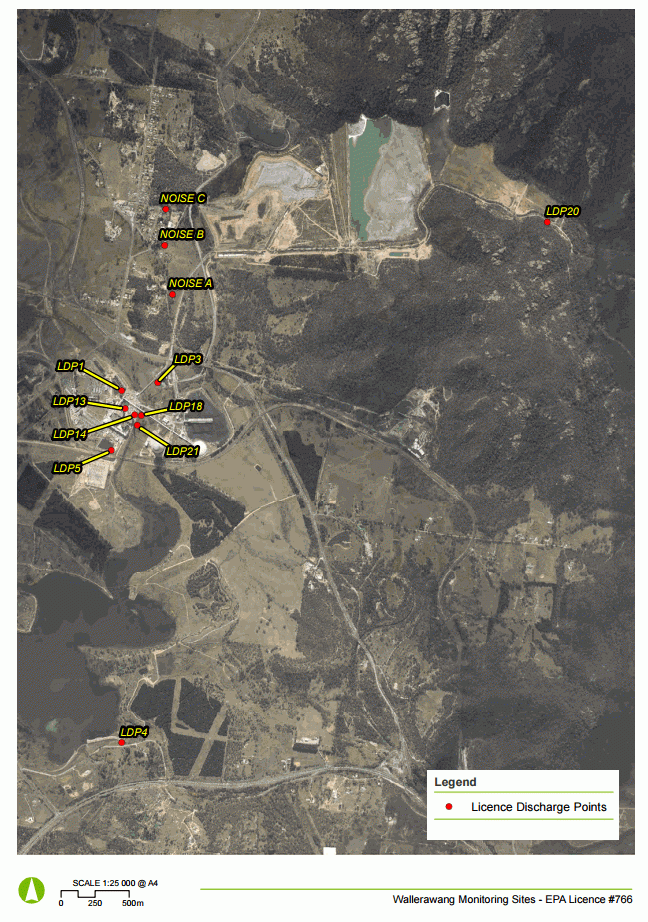
Environment monitoring locations
| Environment Protection Licence Number | EPL ID No Code | Location (Coordinates) | Description |
|---|---|---|---|
| 766 | LDP1 | -33.400984,150.083081 | Discharge to Coxs River from Unit 7 cooling tower identified as "EPA ID 1" on a map provided to the EPA in a letter data 18 March 2005. |
| 766 | LDP13 | -33.40218,150.083311 | Wallerawang Power Station Boiler 7, identified as "EPA ID 13" on a map provided to the EPA in a letter data 18 March 2005. |
| 766 | LDP14 | -33.40261,150.084046 | Wallerawang Power Station Boiler 8, identified as "EPA ID 14" on a map provided to the EPA in a letter data 18 March 2005. |
| 766 | LDP18 | -33.402664,150.084572 | Combined overflow drains from the coal settling basins at Wallerawang Power Station to Coxs River, identified as "EPA ID 18" on a map provided to the EPA in a letter data 18 March 2005. |
| 766 | LDP20 | -33.390621,150.117005 | Centennial-Springvale Water Transfer System bypass point east of Kerosene Vale ash dam. |
| 766 | LDP21 | -33.4033,150.084229 | Emergency discharge point just north of railway bridge and just upstream of ambient monitoring point LDP8. |
| 766 | LDP3 | -33.400528,150.08594 | Caustic injection plant discharge to Coxs River, identified as "EPA ID 3" on a map provided to the EPA in a letter data 18 March 2005. |
| 766 | LDP4 | -33.424274,150.082303 | Discharge to Coxs River from Unit 7 & 8 cooling tower blowdown, identified as "EPA ID 4" on a map provided to the EPA in a letter data 18 March 2005. |
| 766 | LDP5 | -33.404914,150.082128 | Overflow drain from southern retention basin to Coxs River, identified as "EPA ID 5" on a map provided to the EPA in a letter data 18 March 2005. |
| 766 | NOISE A | -33.394719,150.087292 | Measurement location for representative sensitive receiver: 60 Skelly Road, Lidsdale. |
| 766 | NOISE B | -33.391449,150.086777 | Measurement location for representative sensitive receiver: 10 Skelly Road, Lidsdale. |
| 766 | NOISE C | -33.389049,150.086954 | Measurement location for representative sensitive receiver: 21 Neubeck Street, Lidsdal |
Map